Tehsil Kot Momin · District Sargodha · Punjab · Pakistan
Raheem pur
A town on the left bank of the Chenab, inside a circle the old accounts say was closed by seven gates, in the country where Ranjha was born.

The flag of Raheem pur
- 0 km to the River Chenab
- 0 km to Kot Momin
- 0 km to Sargodha city
- 0 m above sea level
- 0 gates of the old circle
- 0 postal code
Distances are by road from the village. Elevation and postal code are the recorded figures for the Takht Hazara settlement.
The place
Two kilometres from the river, and a long way from everywhere else
Raheem pur sits with East Raheem pur and Kot Ghazi Kalan below it, in the cluster of villages that gathers around Midh Ranjha in Tehsil Kot Momin. The Chenab runs about two kilometres to the east. Kot Momin is roughly forty kilometres away, Sargodha city fifty-eight, Islamabad two hundred and forty-seven.
There is no bridge over the Chenab at this point. That single missing structure explains a great deal about the last fifty years here — why the market is in Kot Momin, why the young men work in Sargodha and Lahore and the Gulf, and why the old town on the bank has been emptying out.
Land, river and map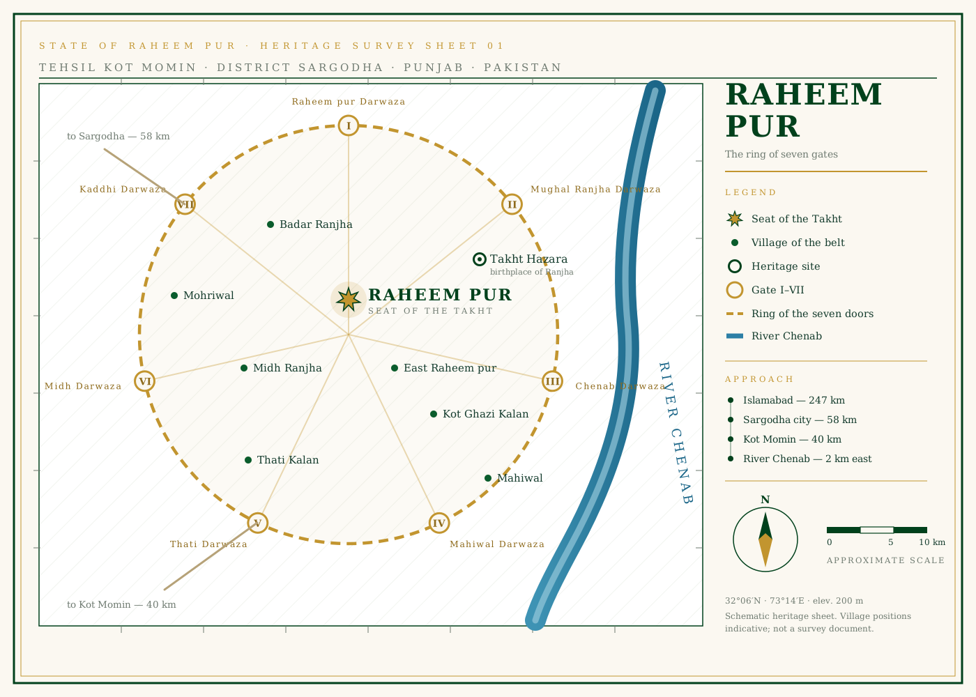
What is here
Four things this ground is known for
The throne
District records call the old settlement Jehangirnagar. The name Takht Hazara came later — a Mughal king’s throne, and the thousand acres the town was said to cover.
02The seven gates
The accounts of Takht Hazara describe seven doors set around a circle of some eighty kilometres. Two of them are named.
03Heer Ranjha
Dhido Ranjha of the Ranjha tribe belonged to Takht Hazara. Waris Shah set him in verse in 1766 and the village has been in Punjabi literature ever since.
04Wheat and kinnow
The kaddhi — the farmed bank of the river — grows wheat and fodder, and Kot Momin tehsil around it is known across Pakistan for its kinnow.
The record
From the Mughal takht to the last census
-
1893 – 1914
Shahpur District, then Sargodha
The British create Shahpur District in 1893. Sargodha is founded as a canal-colony town on 22 February 1903, and in 1914 the district headquarters move there, although the district keeps the name Shahpur.
-
1947
Pakistan
At independence Shahpur District passes to Pakistan. The kaddhi villages along this stretch of the Chenab — Raheem pur among them — become part of West Punjab.
-
1960
The Indus Waters Treaty
Under the treaty signed in 1960 the waters of the Chenab are allocated to Pakistan. For a village that farms the bank, no single document since Partition has mattered more.
-
1960 – 1961
Sargodha District is formed
Sargodha District is created and Shahpur is reduced to one of its tehsils. Sargodha also becomes the headquarters of the division. This is the administrative shape the village still sits inside.
-
2003
Kot Momin becomes a tehsil
On 21 June 2003 Kot Momin is declared a tehsil of Sargodha District. Raheem pur and the whole Takht Hazara belt now answer to Kot Momin rather than to Bhalwal or Sargodha directly.
-
2017
The census
The 2017 census records 4,073 people in Takht Hazara across an area of 2.69 square kilometres, at an elevation of about 200 metres.
-
2020
The people leave
National press reports that the historic town on the bank has lost roughly two thirds of its people in twenty years — from about 15,000 to about 5,000 — as families move away for work. There is no bridge over the Chenab here, and that isolation is part of the reason.
-
2023
The district today
The 2023 count puts Sargodha District at 4,334,448 people over 5,854 square kilometres, roughly 63 per cent of them rural. Raheem pur is one village in that rural majority.
Do you have something for this record?
Old photographs, family names, dates from the mosque or the school, a correction to anything written here — send it and it will be added with your name against it.
Send it in